Artificial intelligence (AI) and machine learning have become major factors in nearly every industry, and have increasingly become more popular among utilities. Automated technology is being used to inspect offshore wind equipment, and to improve electricity management and distribution.
The use of such technologies has a long list of benefits. It specifically can provide experienced power operators with new tools to improve the field connectivity survey process.
Electric utilities have an obligation to map and inspect overhead assets to ensure the electric distribution system is running safely, and so that the location of assets can be identified for future inspections. But the process to conduct field connectivity surveys is a lengthy one, traditionally having been done by operatives walking the electric distribution network and capturing information from the assets manually.
In addition to being time-consuming, other disadvantages of this process include higher operation and maintenance (O&M) costs, and a high probability of capturing inaccurate data. Because the information is being recorded manually, it is subject to human error and is dependent on the skill level, experience, and diligence of inspectors. After capturing the data, subject matter experts review the results and upload them on a geographic information system (GIS) manually–which on its own is a time-consuming and costly process.
AI and machine learning today are becoming part of the electric utility toolbox. By combining "boots on the ground" operatives and subject matter experts with a technology that utilizes AI and machine learning, utilities can create a more streamlined solution for mapping and inspecting overhead electric assets.
AI Technology for Asset Management
While skilled operatives and subject matter experts hold great value in asset management, technology can assist the process by acting as a tool to improve efficiency and quality of work. One of the biggest advantages of using an AI-powered technology is that most of the data collection can be conducted autonomously at highway speed and processed in near real-time, which ultimately reduces manual time spent on surveys, and contributes to lower O&M costs. Using this tool also removes the subjectivity of data and delivers benefits that further improve system reliability.
In addition to improving the process overall, the shift to using technology reflects life in our "new normal" because it contributes to social distancing in the field. The use of AI-powered technology in asset management enables the collection of data with the fewest possible onsite operatives, and provides staff with better tools to complete survey work remotely. The goal of the solution is not to replace operators with machines and software, but to equip them with better tools to improve efficiency and quality of work.
The concept of an AI-powered asset management tool already has moved to the development stage. ULC Robotics developed a solution called Asset Identification and Mapping (AIM), which combines machine learning and a vehicle-mounted data collection system to inspect the overhead distribution network.
 |
|
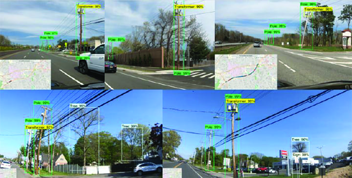
1. Examples of autonomous identification of assets using ULC Robotics' patent-pending Asset Identification and Mapping (AIM) system. Courtesy: ULC Robotics |
AIM hardware is composed of high-resolution cameras and a global positioning system mounted on a ground-based vehicle. The vehicle is driven along a pre-identified route (Figure 1), while cameras and other sensors, which are connected to a computer on the vehicle, collect, store, and process visual data of overhead assets using AI.
The data is processed in real-time, or after the data collection is completed, and results are uploaded to a secure cloud-based server for further assessment and review. A proprietary machine-learning algorithm detects target assets, including poles, transformers, fuses, and switches, in the video footage collected by the cameras. An image processing algorithm also estimates the tilt angle of the poles and stores this information on the cloud as metadata for each pole.
Once an asset is correctly identified, a high-resolution image of the electric pole and its attachments are stored on the cloud for further analysis and use. Through a patent-pending technology, the software measures the accurate global position of each asset, which is then used to autonomously geotag each image.
 |
|
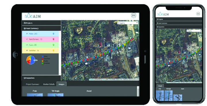
2. A tablet and cellphone version of the AIM user interface can be used by crews working in the field. Courtesy: ULC Robotics |
ULC has also developed a web-based user interface (Figure 2) that allows staff to review the inspection results, make changes, add comments, and generate reports. In the web-based interface, pole locations are marked on a GIS mapping system. The markers on the map are color-coded based on the type of assets identified on each pole. Other information including GPS coordinates, tilt angle, asset phasing, along with high-resolution images of the poles and assets, are stored with each marker for further evaluation and assessment from the office.
With the COVID-19 pandemic, this past year alone has shown the value of reliance on technology in all sectors, which will only continue into the future. AIM is a forward-thinking solution for overhead electric asset management that provides more efficient, cheaper, and accurate digitized asset data than traditional methods used. The technology has been developed in a way that is easy-to-use by electric utilities, and through further development, has potential for other inspection applications in the future.
–Ali Asmari, PhD (aasmari@ulrobotics.com) is head of machine learning at ULC Robotics.
